Cambridgeshire features an extensive network of flat terrain and dedicated infrastructure for cyclists of all abilities. The county terrain consists of two primary topographical regions, including the low-lying northern Fens and the undulating southern chalk hills. Active travel initiatives by the local government provide detailed maps and designated pathways to enhance rural and urban connectivity across the county. This comprehensive guide details the premier paths, structural design frameworks, and safety guidelines required to navigate the regional network efficiently. Cyclists utilize these routes for multi-purpose journeys, including daily commuting, competitive road training, and recreational weekend endurance tracking.
- Why is cycling so popular across Cambridgeshire?
- What are the best flat cycling routes in Cambridgeshire?
- Which long distance road cycling routes start in Cambridge?
- How does infrastructure support active travel in Cambridgeshire?
- What should cyclists know before riding in Cambridgeshire?
- FAQs About Cycling Routes in Cambridgeshire
- Is the Guided Busway cycle path completely paved and safe for road bikes?
- What is the best way to prevent bicycle theft when parking in Cambridge city center?
- Are there any noticeable hill climbs for road cyclists training in Cambridgeshire?
- Can you rent road or electric bikes easily for day trips around the county?
- What are the main recreational highlights along the Wicken Fen cycling circuit?
The history of transport planning in East Anglia underscores a continuous commitment to sustainable, non-motorized infrastructure development. Local councils execute specific development programs, including the Greenways project and the Greater Cambridge partnership agreements, to expand segregated cycling infrastructure. These modern networks interface directly with historical market towns and agricultural corridors to preserve regional travel options without expanding automotive dependence. Understanding the exact spatial layouts and safety protocols ensures that all participants maximize their journey efficiency across regional routes. This analysis provides verified geographical data, distance measurements, and infrastructure descriptions for optimal route selection and successful trip execution.
Why is cycling so popular across Cambridgeshire?
The popularity of cycling across Cambridgeshire stems from the exceptionally flat topography of the terrain, a historically dense student population, and sustained municipal investments in dedicated infrastructure projects, such as segregated cycleways, secure parking hubs, and priority traffic signaling networks.
The geographical layout of East Anglia features minimal elevation changes to facilitate highly efficient bicycle transportation across long distances. The county contains three distinct geological formations, including reclaimed fenlands, river valley floodplains, and gentle chalk hills, which limit steep climbs to less than two percent gradients. This flat terrain directly minimizes the physical exertion required for daily commuting and recreational long-distance endurance rides. Consequently, citizens of all demographics utilize bicycles as their primary mode of short-range transit within urban perimeters. Robust municipal data confirms that the region maintains the highest percentage of regular cyclists across the United Kingdom.
Sociological factors combine with municipal policy to reinforce the active travel culture within the city and outer villages. The presence of the University of Cambridge establishes a permanent demographic of residents who prioritize affordable, emission-free transportation solutions. City planners restrict private vehicular access to ancient city center streets through specific control mechanisms, including rising bollards, camera-monitored bus gates, and low-speed zoning regulations. These active restrictions create a highly protected environment where non-motorized vehicles maintain structural priority over standard commercial traffic. The resulting high bicycle modal share reduces overall urban congestion and lowers localized carbon emission metrics significantly.
What are the best flat cycling routes in Cambridgeshire?
Viviana Escobar
The best flat cycling routes in Cambridgeshire include the Guided Busway cycle path, the A10 off-road corridor to Melbourn, and the Wicken Fen loop, which offer completely segregated, well-paved surfaces ideal for families, commuters, and high-speed endurance training.
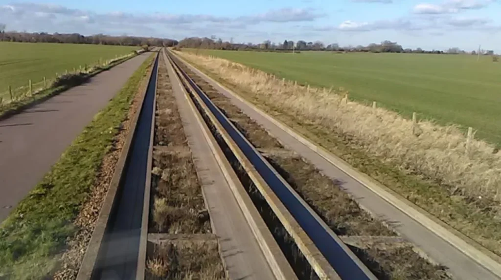
The Guided Busway Cycle Path
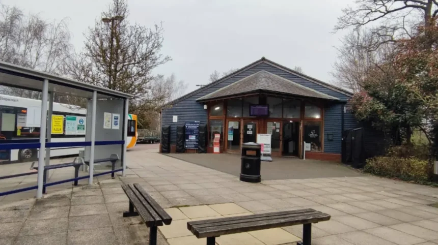
The Guided Busway cycle path represents a premier example of specialized infrastructure providing a completely traffic-free corridor across the county. This route covers a total distance of twenty-six kilometers to connect the market town of St Ives directly with north Cambridge. The path consists of a completely flat, wide bitumen surface running parallel to the dedicated public transit bus tracks. Cyclists utilize this corridor to maintain consistent speeds without encountering intersecting vehicular roadways or hazardous traffic roundabouts. The layout features eight designated parking hubs, including Swavesey, Longstanton, Oakington, and uk/local/histon/">Histon, to facilitate multi-modal regional commuting options.
The northern section of this specialized corridor provides direct access to scenic landscapes and key economic employment centers. The route terminates near major industrial zones, including the Cambridge Science Park and modern development projects near Cambridge North Station, which increases its utility for daily professional commuters. The infrastructure incorporates comprehensive safety elements, including high-intensity LED lighting installations, clear directional signage arrays, and continuous closed-circuit television monitoring. These protective elements ensure a secure travel environment during all seasons and diverse weather conditions across the flat landscape.
The A10 Off-Road Cycle Corridor
The A10 cycling route provides a critical southern transit link that runs completely segregated from adjacent high-speed vehicular traffic corridors. This path has undergone significant expansions to connect diverse rural residential areas with central employment zones and major transport hubs. A notable example includes the off-road route expansion to Melbourn village from Trumpington, which isolates cyclists safely from the busy arterial highway layout. The path features a two-meter wide smooth tarmac surface designed to accommodate multi-directional non-motorized traffic flows seamlessly.
The route serves three major southern villages, including Hauxton, Harston, and Foxton, before terminating in the residential perimeter of Melbourn. This specific connectivity allows rural populations to access urban core infrastructure without relying on private personal automobiles. The path engineering includes advanced safety features, including dropped kerbs, high-visibility reflective surface markings, and specialized priority crossing zones at intersecting rural lanes. These components work together to mitigate the collision risks commonly associated with high-speed rural arterial roadways. The corridor remains a cornerstone of the regional active travel strategy to lower vehicular gridlock south of the city.
The White Fen and Wicken Fen Loop
The White Fen and Wicken Fen loop offers a highly scenic recreational route through the historic heart of the East Anglian wetlands. This path utilizes three distinct trail components, including the National Cycle Network Route 11, rural bridleways, and designated river conservation towpaths. The route begins in the ancient village of Lode, passes near Anglesey Abbey, and extends across the protected peatlands of White Fen. Cyclists experience a completely flat landscape characterized by open vistas, drainage dykes, and traditional agricultural wind pump structures. The path surface features a mix of well-compacted gravel sections and smooth paved asphalt sections suitable for hybrid and touring bicycles.
The destination point at Wicken Fen consists of a highly vital National Trust nature reserve containing unique wetland biodiversity specimens. Visitors utilize specialized timber boardwalks and designated perimeter paths to explore the site safely without disrupting fragile ecological micro-environments. The return leg of the loop follows the beautiful River Cam pathway, entering the northern edge of the historic university city. This scenic water corridor passes active rowing club zones, traditional narrowboat moorings, and expansive open common lands, including Stourbridge Common. The entire loop covers approximately thirty-eight kilometers of flat terrain, presenting an ideal choice for weekend endurance tours and family excursions.
Which long distance road cycling routes start in Cambridge?
The best long-distance road cycling routes starting in Cambridge are the Newmarket loop and the St Neots loop, which take road cyclists through quiet country lanes, undulating chalk ridges, historic villages, and extensive agricultural landscapes across East Anglia.
The Cambridge to Newmarket Loop
The Cambridge to Newmarket loop represents an iconic road cycling circuit that measures approximately seventy-five kilometers in total length. The route exits the eastern perimeter of the city via the dedicated cycle lanes on the historical Newmarket Road. Cyclists navigate through three traditional rural villages, including Stow cum Quy, Swaffham Prior, and Reach, utilizing quiet, well-paved country lanes. The landscape shifts gradually from flat fenland fields into the rolling chalk hills that characterize the border between Cambridgeshire and Suffolk. This transition provides minor elevation adjustments to offer a moderate athletic training challenge for competitive road cyclists.
The midway point of the circuit enters the global center of thoroughbred horse racing within the town of Newmarket. Cyclists ride adjacent to historical equine infrastructure elements, including the famous Warren Hill training gallops, private stud farm estates, and the National Stud facilities. The return leg passes through the historic village of Bottisham, utilizing well-marked roadside paths that feature high-quality asphalt surfaces. This route provides clean lines of sight and minimal vehicular congestion to allow road cyclists to maintain sustained aerodynamic pacing safely. The total duration for this moderate endurance loop ranges between three and four hours depending on localized wind conditions.
The Cambridge to St Neots Loop via St Ives
The western road cycling loop connects the university core with the largest market towns located in the western districts of the county. This route extends over a total distance of ninety-three kilometers, making it a premier choice for advanced endurance athletes. The itinerary utilizes the traffic-free Guided Busway path to travel safely from Cambridge North to the historic town of St Ives. After crossing the famous fourteenth-century bridge at St Ives, the route transitions onto quiet rural lanes heading south and west. The path features three distinct geographic sections, including the Great Ouse river valley, low-lying arable fields, and western clay ridges.
The westernmost destination point is the historical town of St Neots, where cyclists can utilize public park amenities for mid-journey nutrition replenishment. The return journey follows the undulating terrain of the old road networks, passing through the traditional villages of Eltisley and Caxton. This layout exposes riders to historical coaching inn structures, ancient hedgerows, and expansive modern wind farm installations. The route returns to the city via the historical Barton Road cycling path, which features fully segregated lanes for optimal rider safety. This extensive loop provides a thorough survey of the diverse rural topography defining the western boundaries of the county.
How does infrastructure support active travel in Cambridgeshire?
Infrastructure supports active travel in Cambridgeshire through continuous investments in innovative capital projects, including the country’s pioneer cycle street, segregated urban bike lanes, high-capacity secure parking centers, and comprehensive digital tracking networks that prioritize non-motorized transport.
Urban Cycle Lanes and the Chisholm Trail
Urban cycling efficiency inside the city perimeter relies heavily on dedicated spatial segregation protocols that protect riders from heavy commercial vehicles. A primary milestone in urban route planning occurred when englands first cycle street opens in cambridge, creating a priority corridor where bicycles legally dictate traffic speeds. This priority layout completely bars standard commercial vehicles from overtaking non-motorized transport units along the designated residential street corridor. This structural modification reduces collision frequency and increases commuter confidence across dense inner-city neighborhoods.
Ed Hale
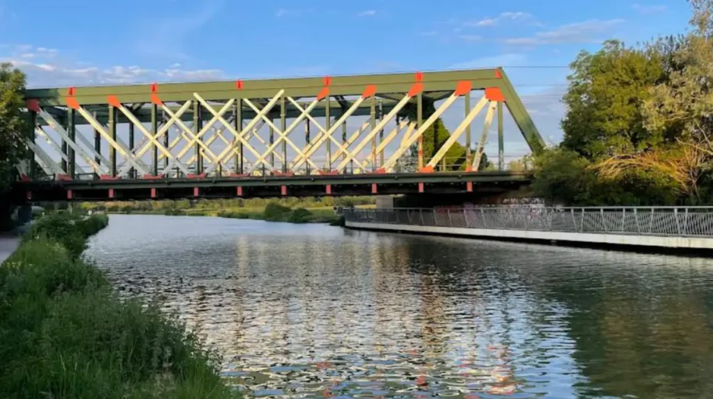
The ongoing development of the Chisholm Trail establishes a high-capacity premier cycling superhighway that bisects the urban core from north to south. This multi-phase infrastructure project utilizes existing rail corridors to construct a completely segregated, multi-user path that avoids complex urban intersections. The layout incorporates custom-engineered components, including the iconic Abbey-Chesterton Bridge over the River Cam, to connect disparate trail networks seamlessly. This design allows users to travel between the primary rail hubs without encountering motorized traffic gridlock or hazardous pedestrian congestion points. The path improves urban logistics by connecting residential sectors directly with central commercial employment centers.
Secure Parking and Security Networks
End-of-journey facilities form a critical component of the regional active travel framework by reducing bicycle theft statistics and encouraging long-duration storage. The city center incorporates specialized high-capacity storage hubs, including the Grand Arcade cycle park, which provides covered spaces for over one thousand bicycles. This indoor facility features advanced security elements, including continuous closed-circuit television monitoring, high-intensity security lighting, and on-site professional maintenance personnel. Dedicated storage bays accommodate specialized non-motorized vehicles, including heavy cargo delivery trikes, family trailers, and adaptive hand-cycles. These secure options allow commuters to leave valuable assets unattended without incurring significant security risks.
Outside the urban center, the local government installs robust parking solutions at all major mass transit rail and bus interchanges across the county. The Guided Busway network features eight distinct covered parking hubs, including St Ives, Longstanton, and Swavesey, containing standardized steel Sheffield stands. Cyclists utilize two distinct lock units, including heavy-duty steel D-locks and flexible cable locks, to secure bicycle frames directly to the ground infrastructure. Owners are encouraged to register unique serial frame numbers on the national bike registration database to facilitate rapid police asset tracking. This integrated security approach supports multi-modal transit schemes by ensuring assets remain safe while commuters utilize public rail services.
What should cyclists know before riding in Cambridgeshire?
Before riding in Cambridgeshire, cyclists should understand localized navigation laws, secure adequate multi-layered locking mechanisms for urban parking, maintain optimal tire pressure for variable rural surfaces, and prepare for strong crosswinds that characterize the open fenland geography.
Navigating the county safely requires strict adherence to localized traffic laws and an understanding of multi-use path etiquette guidelines. Shared-use paths require cyclists to yield structural priority to pedestrians and individuals utilizing mobility assist devices, including wheelchairs and motorized scooters. Cyclists must install two fully independent operating braking units, including front and rear wheel calipers, to comply with national safety regulations. Utilizing high-visibility electronic lighting arrays during hours of darkness is a strict statutory requirement to ensure visibility to commercial motorists. These combined operational rules reduce accident rates and promote harmonious interactions across all active travel participants.
The open geography of East Anglia exposes riders to unique environmental challenges that require specific physical preparation and appropriate equipment selection. The flat fenland expanses lack natural windbreak structures, including dense forests or hill ridges, resulting in high-velocity crosswinds that increase aerodynamic drag significantly. Cyclists must adjust gear selections and maintain firm handlebar positioning when traversing exposed agricultural embankments during winter weather systems. Regular maintenance routines, including lubricating chain links and adjusting tire inflation pressures, prevent mechanical failures along isolated rural pathways. Preparing for these specific environmental conditions ensures consistent travel times and protects structural equipment longevity over extended distances.
FAQs About Cycling Routes in Cambridgeshire
Is the Guided Busway cycle path completely paved and safe for road bikes?
The Guided Busway cycle path consists of a fully blacktopped bitumen surface over its entire twenty-six kilometer length from St Ives to Cambridge. It provides a smooth, flat, and completely traffic-free environment that accommodates standard narrow-tire road racing bikes seamlessly during all weather seasons.
What is the best way to prevent bicycle theft when parking in Cambridge city center?
Cyclists must secure their asset using two distinct high-quality locks, incorporating at least one robust D-lock that anchors the frame and wheels tightly to an official Sheffield stand. Utilizing secure, well-lit indoor hubs like the Grand Arcade cycle park with closed-circuit television monitoring reduces theft probabilities significantly.
Are there any noticeable hill climbs for road cyclists training in Cambridgeshire?
Cambridgeshire is predominantly flat, but the southern chalklands feature minor undulating inclines suitable for interval training loops. Notable elevation changes occur around Chapel Hill near Haslingfield and Madingley Hill to the west, presenting short gradients that range between four and eight percent.
Can you rent road or electric bikes easily for day trips around the county?
he city features multiple bike share and standard rental systems, including app-accessible Voi e-bikes distributed across urban zones and traditional merchants like City Cycle Hire at Lammas Land. These outlets provide immediate short-term or long-term equipment rentals alongside essential safety accessories like helmets and locks.
What are the main recreational highlights along the Wicken Fen cycling circuit?
The circuit exposes riders to vital ecological landscapes, historic working wind pump installations, and unique wetland habitats managed by the National Trust. The pathway loops past Anglesey Abbey estate landscapes and follows the scenic River Cam back into the city alongside active rowing club boathouses.