Hidden villages in Cambridgeshire are historically preserved, low-density rural settlements characterized by restrictive conservation boundaries, high concentrations of listed structures, and geographical insulation from major arterial motorways. These specific settlements retain their architectural heritage due to historic isolation from industrial transport links.
- Why Do These Specific Rural Settlements Hold Significant Historical Value?
- Which Are the Prettiest Hidden Villages in Cambridgeshire to Visit?
- What Architectural Features Define Easton and Lode?
- How Do Abbotts Ripton and Houghton Preserve Their Heritage?
- What Makes The Hemingfords Unique Settlements?
- How Do Modern Infrastructure and Commuting Patterns Impact These Areas?
- What Environmental Pressures Threaten the Preservation of These Villages?
- FAQs About Hidden Villages in Cambridgeshire
- What Is the Best Time of Year to Visit Hidden Villages in Cambridgeshire?
- Are Public Transport Options Available for All Cambridgeshire Villages?
- How Can Visitors Find Historic Walking Routes Between the Settlements?
- What Structural Protections Apply to Thatched Cottages in Conservation Areas?
- Do Local Communities Host Public Events to Support Heritage Preservation?
The geographic landscape of Cambridgeshire splits into distinct topographical regions that directly influenced how early populations settled the land. The northern section comprises the flat Fens, a region featuring rich, dark peat and silty soils that required extensive drainage systems engineered during the seventeenth century. Settlements in this northern territory developed on localized islands of elevated clay or gravel, which kept residents safe from seasonal marshland flooding. The southern territory consists of chalk hills and clay plateaus, supporting linear settlement patterns along river valleys. These variations in geology determined whether a village used timber frame construction, clunch (hardened chalk blocks), or local fieldstones.
Sociological shifts continuously alter the demographic profile of these rural communities. Historically dependent on agriculture and drainage labor, modern villages serve as residential hubs for professionals working in technical sectors. The growth of research facilities, such as the Cambridge Science Park, creates demand for residential real estate within an achievable commuting radius. This economic transition converts working agricultural communities into affluent commuter enclaves while preserving the physical structures of the past. Strict planning protections prevent modern developments from destroying the core layouts of these settlements.
Preservation occurs through institutional designations managed by local planning authorities, including South Cambridgeshire District Council and East Cambridgeshire District Council. Conservation area designations protect entire streetscapes, preventing changes to property boundaries, roof heights, and historic building materials. Listed building statuses safeguard individual properties from unauthorized alterations, ensuring that centuries-old construction methods survive. These regulations ensure that the physical history of the county remains intact for future generations.
Why Do These Specific Rural Settlements Hold Significant Historical Value?
These rural settlements hold historical value because they contain uninterrupted architectural records spanning the Anglo-Saxon, medieval, and early modern periods. The physical structures serve as primary evidence of changing agricultural systems, domestic building techniques, and regional trade routes over one thousand years.
Archaeological records show that the location of Cambridgeshire settlements depends on access to fresh water and trade routes. The river networks, including the Cam and the Great Ouse, functioned as primary transport routes during the Roman and Anglo-Saxon eras. Settlements built along these waterways handled the transport of agricultural goods, timber, and building stone. Excavations reveal evidence of early pottery manufacture, metalworking hearths, and managed fishponds. These findings prove that rural settlements operated as self-sufficient economic centers before urban growth centralized regional trade.
The architectural transition of residential homes highlights changes in economic conditions and the availability of building materials. Surviving fourteenth-century structures use timber-frame techniques, relying on native oak beams joined by wooden pegs. The walls use wattle and daub, a mixture of woven hazel twigs, clay, straw, and animal manure. As local woodland declined during the sixteenth century, builders turned to clunch and locally fired brick. Roof designs changed based on economic status, with reeds from the marshlands providing cheap insulation for working-class cottages, while wealthy landowners imported slate or tile.
The Domesday Book of 1086 provides the first systematic record of landholder names, livestock totals, and mill quantities across the county. This fiscal survey shows that many hidden villages already possessed organized open-field farming systems before the Norman Conquest. The Black Death in 1348 disrupted these systems, causing population losses that forced landowners to switch from crop farming to sheep grazing. This economic shift changed village layouts, leaving empty plots that help modern historians map medieval population sizes.
Read More: To see how historical preservation connects to urban cultural institutions, view our guide on Cambridge museums historical value.
Which Are the Prettiest Hidden Villages in Cambridgeshire to Visit?
The prettiest hidden villages in Cambridgeshire include Easton, Lode, Abbotts Ripton, Houghton, and the Hemingfords. These specific settlements preserve authentic regional architecture, historic water systems, and original medieval layouts.
What Architectural Features Define Easton and Lode?
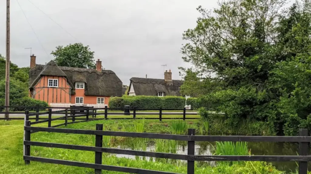
Easton is a small, secluded village situated on the western border of Cambridgeshire, characterized by single-file roads and timber-framed cottages. The defining feature of the settlement is a network of open waterways running alongside the main roads, crossed by small private footbridges. These channels historically managed surface water runoff from the surrounding clay plateaus into local streams. The village contains numerous seventeenth-century thatched cottages with exposed timber framing and traditional lime wash finishes. This layout preserves the design of an isolated farming hamlet that avoided modern widening projects.
Lode is located on the eastern edge of the county, where the chalk uplands meet the flat fen basin. The village layout follows Lode Water, a man-made canal dating back to the Roman era used to transport goods to the River Cam. Lode contains Anglesey Abbey, a historic country house built on the remains of a twelfth-century Augustinian priory. The surrounding village architecture features a mixture of dark local brick and traditional thatch roofs. The watermill within the village, restored to operational order, demonstrates eighteenth-century engineering techniques used to grind grain using river power.
How Do Abbotts Ripton and Houghton Preserve Their Heritage?
Abbotts Ripton sits north of Huntingdon and features a high concentration of continuous thatched roofs. The village belongs to a managed estate, an ownership structure that prevented individual modern redevelopments during the twentieth century. The cottages display decorative ridge thatching, timber beams, and uniform color schemes that match the historic estate identity. Wisteria plantings and mature magnolia trees line the brick paths, creating a uniform visual landscape. The village church, built using rubble and stone, dates to the thirteenth century and marks the geographic center of the parish.
Houghton is situated on the banks of the Great Ouse and contains the last working flour mill on the river. This national trust property demonstrates how Victorian industrial expansion integrated into rural river settlements. The center of the village features a traditional square with a thatched clock tower surrounded by historic public houses. The residential streets contain examples of early brickwork and timber frames, showing how local building styles evolved over four hundred years. The lack of through-traffic preserves a quiet environment along the river banks.
What Makes The Hemingfords Unique Settlements?
The settlements of Hemingford Abbots and Hemingford Grey sit next to each other along the southern floodplains of the Great Ouse. A five-minute walk across open water meadows connects the two parishes, highlighting the historic links between neighboring riverside communities. Hemingford Abbots contains a high concentration of large, thatched houses and an active village church with a fourteenth-century spire. The local public house, the Axe and Compass, uses a seventeenth-century timber frame structure that still serves its original purpose.
Hemingford Grey features The Manor, which stands as one of the oldest continuously inhabited residential structures in Britain. Built around the year 1130, this moated house retains its original Norman stone walls and two-foot-thick architectural defensive features. The surrounding village properties line the riverbank, displaying a mix of Georgian facades and older timber-framed structures. The local lock system and flood defenses show how the community adapted to seasonal changes in river levels over several centuries. This combination of structural ages provides a physical record of domestic architectural history.
Related Article: Visitors exploring the riverside pathways can find out more about regional water recreation by reading our definitive guide to Cambridge punting.
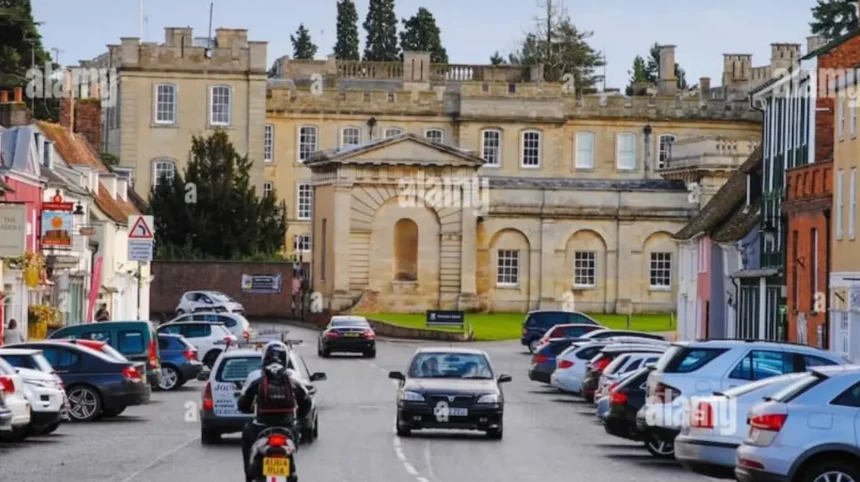
How Do Modern Infrastructure and Commuting Patterns Impact These Areas?
Modern infrastructure impacts these areas by introducing commuter populations, raising property values, and placing increased demand on historic road networks. These changes create a clear economic division between residential property use and traditional rural infrastructure.

The development of the Cambridge Science Park and the expansion of biological research centers alter regional housing demographics. Employees in these sectors seek homes in nearby villages, driving up property prices beyond the reach of local agricultural workers. This demand changes old farmhouses into residential properties, altering the social makeup of these communities. The arrival of wealthy residents funds the restoration of historic buildings, ensuring their survival but reducing housing options for younger local families.
Transport projects, including the Cambridgeshire Guided Busway and improvements to the A14 expressway, alter village connectivity. Settlements near busway stations experience rapid commuter housing growth, changing their character from isolated hamlets into commuter developments. Villages without direct access to transport routes escape major developments but face increased traffic on narrow lanes designed for horses and carts. This traffic damages historic stone bridges and causes vibration risks to the foundations of old thatched cottages.
The loss of local amenities represents a major change across these rural areas. As residents use urban supermarkets and online delivery services, village shops, post offices, and independent businesses face closure. Surviving businesses often change their models to serve visitors, turning traditional pubs into destination restaurants. This shift leaves residents dependent on private cars or limited bus services to access basic medical and commercial facilities.
Read More: Discover how the wider county accommodates remote workers by visiting our guide on visiting as a digital nomad.
What Environmental Pressures Threaten the Preservation of These Villages?
Environmental pressures threaten preservation through increased flood risks, changing water tables, and accelerated decay of traditional building materials. These issues require ongoing management from conservation groups and property owners to prevent permanent structural damage.
Climate shifts cause intense winter rainfall events, overwhelming historic drainage ditches and raising river levels along the Great Ouse and Cam valleys. Low-lying properties in villages like the Hemingfords face regular flood risks, requiring the installation of modern barriers. These defenses must protect the buildings without damaging historic timbers or lime plaster. Rising water levels also threaten nearby agricultural land, putting pressure on old fen pump systems.
Drying clay soils pose a major threat to properties built without deep modern foundations. Hot summers cause clay subsoils to shrink, leading to subsidence and structural cracking in brick and clunch walls. Repairing this damage requires lime injection methods that allow old structures to flex naturally with seasonal ground movements. Using modern concrete to fix these issues often seals in moisture, accelerating the rot of internal timber frames.
The lack of traditional building materials complicates ongoing preservation work. Thatched roofs require marsh reeds or long straw, which face supply shortages due to changing agricultural practices. The decline in trained apprentices limits the availability of specialized workers who understand historic framing and plastering techniques. Property owners face high maintenance costs to meet conservation standards, creating financial challenges for long-term preservation.
FAQs About Hidden Villages in Cambridgeshire
What Is the Best Time of Year to Visit Hidden Villages in Cambridgeshire?
The best time of year to visit hidden villages in Cambridgeshire is between May and September when weather conditions support outdoor exploration. This period ensures that unpaved walking routes, river paths, and historic garden attractions remain open to the public. Summer operating schedules also mean that local heritage sites and watermills run regular demonstrations for visitors.
Are Public Transport Options Available for All Cambridgeshire Villages?
Public transport options are not available for all Cambridgeshire villages due to the isolation of smaller settlements. Larger commuter hubs feature regular bus services and connections via the Cambridgeshire Guided Busway network. Reaching smaller settlements, such as Easton, requires private transport because narrow roads cannot accommodate standard public bus routes.
How Can Visitors Find Historic Walking Routes Between the Settlements?
Visitors can find historic walking routes between the settlements by using official Ordnance Survey maps that show public rights of way. The Ouse Valley Way and the Fen Edge Trail offer marked pathways connecting riverside parishes and historic fen islands. Local parish councils also display maps on village greens showing public footpaths across agricultural land.
What Structural Protections Apply to Thatched Cottages in Conservation Areas?
Structural protections applying to thatched cottages in conservation areas require owners to obtain formal consent before altering roofs. These regulations cover the thickness of the thatch, the choice of material, and the design of the ridge detailing. Property owners must use traditional materials to maintain the historic appearance of the settlement.
Do Local Communities Host Public Events to Support Heritage Preservation?
Local communities host public events to support heritage preservation, including summer open-garden weekends and autumn harvest festivals. These events raise maintenance funds for medieval parish churches and community-managed historical sites. These gatherings help preserve local traditions and allow visitors to see private historic properties.