

Key Points
- Graham has completed the A10 bridge linking Waterbeach New Town with Cambridge Science Park and Cambridge city centre.
- The structure is a pedestrian, cycle and equestrian bridge spanning the A10 near Waterbeach, forming a predominantly off‑road active travel route.
- The bridge was fabricated off‑site and lifted into place during weekend closures of the A10, with the largest section weighing 70 tonnes and measuring 28 metres.
- The project was commissioned by developer Urban&Civic, with Graham as principal contractor and Stantec providing detailed structural design.
- The bridge opened to users in early 2026, with an official inauguration held in May 2026 after landscaping was completed.
- The route connects Waterbeach to Landbeach, Cambridge Regional College, Cambridge Science Park and onward into the city via the upgraded Mere Way and proposed busway.
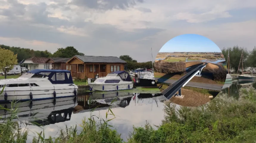
- The 90‑metre steel bridge, weighing around 150 tonnes, was designed to reflect Waterbeach’s aviation history and integrate with the landscape.
- Fiona Reardon‑Rose of Urban&Civic said the link already enables residents to access jobs in Landbeach and vice versa.
City Centre (Cambridge Tribune) July 2026 – Graham has completed the A10 bridge linking Waterbeach New Town and Cambridge city centre, delivering a traffic‑free crossing for pedestrians, cyclists and horse riders over one of the region’s busiest roads. The structure forms the final element of a predominantly off‑road route from the growing Waterbeach development through to Cambridge Science Park, Cambridge Regional College and into the city via the upgraded Mere Way and planned busway. The bridge, which opened to users in early 2026 and was formally inaugurated in May 2026, marks a significant milestone in the active travel infrastructure supporting the new town.
- Key Points
- How was the A10 bridge at Waterbeach designed and built?
- Who commissioned and delivered the Waterbeach A10 bridge?
- When did the A10 bridge open and what route does it complete?
- What has been said about the bridge’s impact on travel and communities?
- Background of the development
- Prediction: how this development may affect commuters, residents and planners
How was the A10 bridge at Waterbeach designed and built?
As reported by multiple outlets, the 90‑metre steel bridge weighs approximately 150 tonnes and was designed to reflect Waterbeach’s aviation heritage while integrating with the surrounding landscape. The design features sculpted edge beams and deck and parapet sections that create a distinctive silhouette, with gentle slopes and vegetated embankments to provide safe, accessible crossing points. To minimise disruption on the A10, the bridge was largely fabricated off‑site and installed in modular sections. The largest single segment weighed 70 tonnes and measured 28 metres, and was positioned using a 650‑tonne crane during weekend road closures. Construction teams worked in shifts around the clock over three consecutive weekends in September 2025 to complete the installation and finishing works, according to project communications.
Who commissioned and delivered the Waterbeach A10 bridge?
The project was commissioned by Urban&Civic, the master developer behind Waterbeach New Town, with Graham appointed as principal contractor for the pedestrian, cycle and equestrian bridge. Stantec provided the detailed structural design for the bridge, which connects active travel routes across the A10 corridor in Cambridgeshire. Rebecca Britton, associated with Urban&Civic Waterbeach, described the bridge as an “elegant and sculptural addition to the setting” and emphasised its role in making active travel intrinsic to the new town. Fiona Reardon‑Rose of Urban&Civic said the link is already being used by residents accessing employment in Landbeach and by workers travelling in the opposite direction.
When did the A10 bridge open and what route does it complete?
The pedestrian, cycle and equestrian bridge over the A10 opened to users in early 2026, with Waterbeach residents among the first to walk and cycle across it. Although the official launch was held in May 2026 after landscaping was completed, the bridge had been in use since the previous month, providing a direct, largely off‑road connection from Waterbeach to Cambridge Science Park, Cambridge Regional College and onward to the city. The route connects the new town to Landbeach and Cambridge via the upgraded Mere Way and the proposed new busway, creating a continuous active travel corridor.
What has been said about the bridge’s impact on travel and communities?
Fiona Reardon‑Rose of Urban&Civic stated, “We’ve already observed that residents from the new town are finding employment opportunities in Landbeach, and the same applies in reverse,” highlighting early two‑way movement enabled by the bridge. Project materials note that the bridge supports Urban&Civic’s vision for sustainable travel, making walking, cycling and riding viable options for residents and workers in the area. The bridge’s completion is presented as a significant milestone in the development of sustainable infrastructure in the region, aligning with broader plans for low‑carbon transport around Waterbeach and Cambridge.
Background of the development
The A10 bridge at Waterbeach is part of the wider Waterbeach New Town project, a large‑scale mixed‑use development on the site of the former Waterbeach Barracks and Airfield. Urban&Civic is the master developer, with plans for thousands of new homes, employment space, schools and community facilities, alongside extensive green infrastructure and active travel networks. The bridge was identified as a key element of the active travel strategy, intended to connect the new town to existing settlements and employment hubs without requiring users to cross the busy A10 at grade. Graham was appointed as principal contractor in early 2025, with works scheduled to commence in February 2025 and be completed by early 2026. The A10 was closed for three consecutive weekends in September 2025 to allow the bridge to be lifted into place and finishing works to be carried out. The structure was designed to integrate with the local landscape and to reflect the site’s aviation history, with sculpted forms and vegetated embankments. Completion of the bridge enabled the delivery of a predominantly off‑road route from Waterbeach through to Cambridge Science Park and the city, supporting the development’s sustainability objectives.
Prediction: how this development may affect commuters, residents and planners
For daily commuters and local residents, the completed A10 bridge is likely to increase the share of journeys made by walking, cycling and riding between Waterbeach, Landbeach and Cambridge, particularly for trips to the Science Park, Cambridge Regional College and the city centre. By providing a traffic‑free crossing, the bridge reduces perceived safety barriers associated with the A10 and may encourage more people to choose active travel over short car trips, potentially lowering local congestion and emissions over time. For employers in the Science Park and city centre, improved active travel links could widen the accessible labour pool from Waterbeach and nearby villages, supporting recruitment and reducing reliance on car parking. For urban planners and developers in the Cambridge region, the project may serve as a reference case for integrating substantial active travel infrastructure at the early stages of new town delivery, influencing design standards for future crossings and green corridors. If usage patterns reported by Urban&Civic continue to grow, the route could also support complementary investments such as enhanced lighting, wayfinding and connections to local bus services, further strengthening the role of sustainable transport in the area.