

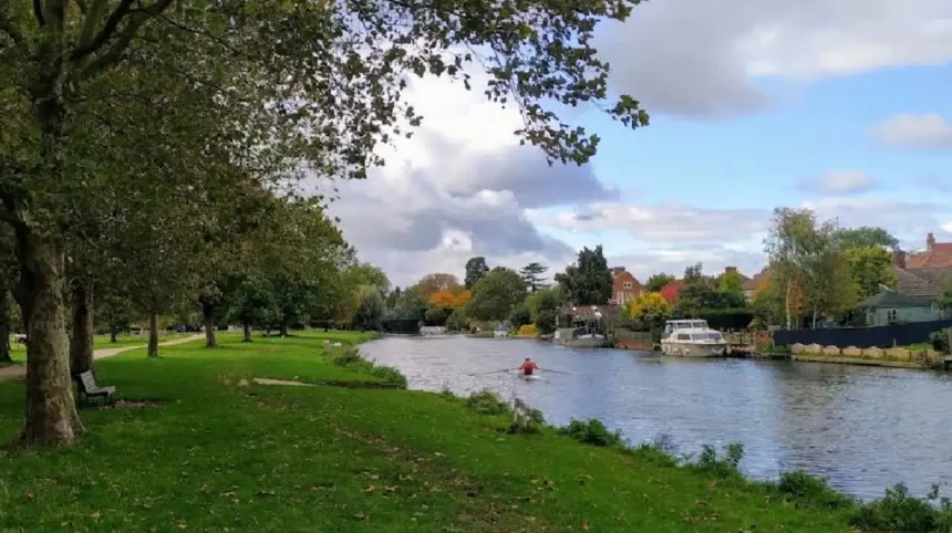
Cambridge is widely known for its historic colleges, but its riverside landscapes offer an equally rewarding experience. The Stourbridge Common to Fen Ditton scenic riverside walking trail follows a peaceful stretch of the River Cam through open meadows, historic commons, nature reserves, and one of Cambridgeshire’s oldest villages. The largely flat route suits walkers of different ages and fitness levels while providing excellent opportunities for wildlife watching, photography, and quiet recreation. The trail combines natural beauty with centuries of local history, making it one of the area’s most enjoyable outdoor walks.
- What is the Stourbridge Common to Fen Ditton scenic riverside walking trail?
- Why is Stourbridge Common historically significant?
- What natural features make this riverside walk unique?
- How long is the walk from Stourbridge Common to Fen Ditton and what can visitors expect?
- What wildlife and habitats can visitors discover along the route?
- Is the Stourbridge Common to Fen Ditton walk suitable for families and visitors throughout the year?
- What practical information should visitors know before walking from Stourbridge Common to Fen Ditton?
- How does the Stourbridge Common to Fen Ditton trail support Cambridge’s heritage and conservation?
- Frequently Asked Questions
- Is the Stourbridge Common to Fen Ditton walk free to access?
- What is the best time of year to walk from Stourbridge Common to Fen Ditton?
- Can dogs accompany visitors on the trail?
- What wildlife is commonly seen on the Stourbridge Common to Fen Ditton trail?
- How does this trail differ from other Cambridge walking routes?
What is the Stourbridge Common to Fen Ditton scenic riverside walking trail?
The Stourbridge Common to Fen Ditton scenic riverside walking trail is a riverside route in eastern Cambridge that follows the River Cam through protected green spaces, historic landscapes, and Fen Ditton village, offering an accessible walk rich in wildlife, heritage, and countryside views.
The walking route begins around Stourbridge Common, one of Cambridge’s largest public open spaces situated on the eastern side of the city. The common forms part of an extensive green corridor alongside the River Cam that connects urban Cambridge with the surrounding countryside. The route continues eastwards through Ditton Meadows before reaching the historic village of Fen Ditton, creating a continuous riverside experience that remains popular throughout the year.
The trail is largely level, making it suitable for casual walkers, families, runners, and cyclists using designated shared sections. The riverside paths provide uninterrupted views across floodplain meadows while remaining close to the water for much of the journey. Visitors regularly encounter rowing crews, narrowboats, paddleboarders, and local wildlife along this section of the River Cam.
The surrounding landscape is protected because of its ecological importance. Parts of Stourbridge Common have local nature reserve status, supporting rare habitats associated with chalk streams and floodplain grasslands. This combination of conservation, recreation, and history makes the route one of Cambridge’s most valuable green spaces.
Why is Stourbridge Common historically significant?
Stourbridge Common holds exceptional historical importance because it hosted Stourbridge Fair, one of medieval Europe’s largest annual trade fairs, transforming Cambridge into a major commercial centre for more than seven centuries.
The history of Stourbridge Common stretches back hundreds of years. King John granted a royal charter in 1211 allowing a fair to be held near the Leper Chapel at Steresbrigge. Over time, this event expanded into Stourbridge Fair, attracting merchants from across Britain and continental Europe. The fair became one of the most significant trading events of the medieval period and contributed greatly to Cambridge’s economic development.
Historical accounts describe thousands of temporary market stalls selling cloth, grain, livestock, timber, metal goods, spices, books, and imported products. During its peak in the fourteenth through eighteenth centuries, the fair operated as a temporary commercial town built on the common. Contemporary writer Daniel Defoe described it as one of the world’s greatest fairs because of its remarkable scale and diversity of trade.
Although the fair gradually declined during the nineteenth century because of railway expansion and changing trade patterns, its legacy remains visible today. Street names including Garlic Row, Mercers Row, and Oyster Row preserve memories of the historic marketplace, while annual heritage events continue celebrating this important chapter in Cambridge’s history. The fair was formally abolished in 1934 after more than 700 years.
What natural features make this riverside walk unique?
The trail combines riverside habitats, chalk stream ecosystems, floodplain meadows, grazing grasslands, mature trees, and protected wildlife areas, creating one of the richest natural landscapes within the Cambridge area.
The River Cam shapes every section of this walking route. Seasonal flooding supports nutrient-rich grasslands that provide ideal habitats for numerous plant and animal species. Conservation management includes summer cattle grazing, which maintains a healthy balance of grasses and wildflowers while encouraging greater biodiversity across the common.
Coldham’s Brook joins the River Cam within the reserve and represents an important chalk stream ecosystem. Chalk streams are internationally rare freshwater habitats known for exceptionally clear water, diverse aquatic plants, and healthy fish populations. Their conservation remains a priority because only a limited number exist worldwide, with England containing most of the global resource.
Wildlife enthusiasts regularly observe kingfishers, grey herons, little grebes, grey wagtails, kestrels, water voles, bullhead fish, banded demoiselle damselflies, frogs, and newts throughout the reserve. The combination of wetland habitats, open meadows, woodland edges, and riverside vegetation creates ideal conditions for birds, mammals, insects, and amphibians throughout the changing seasons.
How long is the walk from Stourbridge Common to Fen Ditton and what can visitors expect?
The walk from Stourbridge Common to Fen Ditton covers approximately 4 to 4.2 kilometres as a circular route, taking around 50 to 60 minutes to complete while passing riverside meadows, open grassland, historic landmarks, and scenic viewpoints along the River Cam.
The trail begins at Stourbridge Common, where wide open grassland meets the River Cam before continuing east through Ditton Meadows. Most visitors follow the riverside path, which remains level and easy to navigate throughout the year. The route is suitable for beginners, families with children, recreational walkers, and runners because there are very few steep sections.
One of the highlights is Ditton Meadows, an attractive stretch of traditional water meadows lying between Stourbridge Common and Fen Ditton. These meadows provide uninterrupted views across the floodplain while preserving the rural character that has defined this landscape for centuries. During spring and summer, grazing cattle and seasonal wildflowers enhance the natural scenery.
The riverside path forms part of Cambridge’s wider green corridor, linking the city centre with surrounding countryside. Mature willow trees, rowing crews on the River Cam, historic bridges, and quiet picnic areas create varied scenery throughout the walk. Several benches along the route allow visitors to pause and enjoy views across the river without leaving the main path.
Fen Ditton marks the eastern point of the walk and offers a peaceful riverside village atmosphere. The historic parish church of St Mary overlooks the River Cam from higher ground, while traditional cottages and open greens preserve much of the village’s historic appearance. Many walkers choose to rest in the village before returning along the opposite side of the river or retracing their original route.
What wildlife and habitats can visitors discover along the route?
The Stourbridge Common to Fen Ditton route supports diverse wildlife because its rivers, floodplain meadows, chalk stream habitats, mature trees, and seasonal wetlands create ideal conditions for birds, mammals, insects, amphibians, and native plant communities throughout the year.
Stourbridge Common Local Nature Reserve protects an important section of Cambridge’s ecological network. Seasonal flooding enriches the grassland with nutrients that support diverse flowering plants and insects. Conservation grazing by cattle creates varied vegetation heights, improving habitats for butterflies, grasshoppers, beetles, bats, and small mammals.
Birdwatchers frequently observe kestrels hovering above the grassland while hunting field voles. Grey herons, kingfishers, little grebes, swans, ducks, woodpeckers, wagtails, magpies, and jays also inhabit the riverside environment. Winter flooding attracts additional wetland species including snipe and migrating waterfowl that rely on temporary pools created across the common.
The reserve also supports healthy amphibian populations. Frogs, common newts, grass snakes, dragonflies, damselflies, and numerous aquatic insects thrive within ponds, shallow scrapes, and Coldham’s Brook. These habitats contribute to the area’s ecological importance and demonstrate why the common remains actively managed for biodiversity conservation.
Beyond its wildlife value, the riverside landscape functions as an important green corridor connecting central Cambridge with surrounding countryside. This continuous habitat enables wildlife movement while providing residents and visitors with one of the city’s most accessible natural environments for recreation, education, and nature observation.
Is the Stourbridge Common to Fen Ditton walk suitable for families and visitors throughout the year?
The Stourbridge Common to Fen Ditton walking trail is suitable throughout the year because it offers accessible riverside paths, gentle terrain, abundant green space, and changing seasonal scenery that appeals to families, walkers, runners, cyclists, photographers, and wildlife enthusiasts.
The route is one of the most accessible outdoor walks in Cambridge. Most of the riverside pathway is flat, well maintained, and suitable for wheelchair users and pushchairs, particularly between Riverside, Green Dragon Bridge, and Ditton Meadows. Multiple access points from Water Street, Oyster Row, and Riverside allow visitors to join the trail at different locations depending on their preferred walking distance.
Spring transforms the meadows with fresh grass, blossoming hedgerows, and increased bird activity. During summer, grazing cattle help manage the grassland while butterflies, dragonflies, and damselflies become increasingly visible across the reserve. Autumn introduces colourful foliage along the River Cam, and winter flooding creates seasonal wetlands that attract migratory birds and enhance the natural character of the landscape.
Families appreciate the combination of open spaces and riverside safety. Children can observe rowing boats, swans, ducks, and grazing cattle while learning about local wildlife and conservation. Photographers frequently visit during sunrise and sunset when reflections across the River Cam create some of the most recognisable landscape views in eastern Cambridge. The peaceful surroundings also make the trail popular for jogging, dog walking, and quiet recreation throughout every season.
Unlike many countryside walks, this trail remains closely connected to Cambridge’s transport network. Nearby bus services, Cambridge North railway station, and pedestrian links from the city centre allow visitors to reach the route without relying on private transport. The combination of accessibility, historic landscapes, and protected natural habitats makes it one of Cambridge’s most inclusive outdoor destinations.
What practical information should visitors know before walking from Stourbridge Common to Fen Ditton?

Visitors should prepare for a comfortable riverside walk by wearing suitable footwear, checking weather conditions, respecting grazing livestock, following marked paths, and allowing sufficient time to enjoy the area’s history, wildlife, and scenic viewpoints.
The route remains relatively easy to follow because it follows the River Cam for most of its length. Comfortable walking shoes are recommended, particularly after periods of heavy rainfall when sections of the grassland can become muddy. Waterproof footwear is beneficial during winter because floodplain meadows naturally retain water after seasonal flooding.
Several entrances provide flexible access depending on where visitors begin their journey. Popular starting points include Water Street, Riverside, Oyster Row, and Green Dragon Bridge. Limited on street parking is available nearby, while many visitors arrive by bicycle or public transport because Cambridge’s cycle network connects directly with the riverside corridor.
Dogs are welcome throughout most of the route, although owners should keep them under control when cattle are grazing during the summer conservation season. Visitors are encouraged to remain on established footpaths to protect sensitive grassland habitats and minimise disturbance to nesting birds and other wildlife that depend upon these protected environments.
Many walkers extend their visit by exploring the historic village of Fen Ditton, enjoying riverside viewpoints, or connecting with longer walking routes such as the Fen Edge Trail and Fen Rivers Way. These links allow visitors to continue beyond Fen Ditton while experiencing more of Cambridgeshire’s countryside, historic villages, and River Cam landscapes.
How does the Stourbridge Common to Fen Ditton trail support Cambridge’s heritage and conservation?
The Stourbridge Common to Fen Ditton trail preserves an exceptional combination of historic landscapes, protected habitats, and public recreation, ensuring that Cambridge’s cultural heritage and natural environment remain accessible for education, conservation, and sustainable outdoor enjoyment.
Stourbridge Common forms part of one of Cambridge’s most significant green corridors, linking the city with the surrounding fens through continuous riverside habitats. The common is designated as a Local Nature Reserve and Conservation Area, protecting its floodplain grasslands, chalk stream habitats, and historic landscape from inappropriate development. Conservation management balances biodiversity with public access, allowing thousands of visitors to enjoy the area while preserving its ecological value.
The adjoining Ditton Meadows extend this protected landscape towards Fen Ditton, creating an uninterrupted riverside setting that has remained largely unchanged for centuries. Surveys by the Cambridge Natural History Society recorded more than 370 plant species across the meadows, highlighting their remarkable botanical diversity. Seasonal cattle grazing, wetland management, and habitat restoration continue to support native flora and fauna while maintaining the traditional appearance of the floodplain.
Fen Ditton itself contributes an important historical dimension to the walk. Archaeological evidence shows human activity dating back to the Neolithic period, while the village’s medieval wharf played a vital role in transporting goods destined for the famous Stourbridge Fair. Today, the riverside church, historic cottages, and open meadows preserve the character of one of Cambridgeshire’s oldest settlements.
The continued protection of this landscape demonstrates how heritage conservation and environmental stewardship can work together. Visitors experience medieval history, traditional grazing meadows, internationally significant chalk stream habitats, and the River Cam within a single walk. This combination makes the Stourbridge Common to Fen Ditton route one of Cambridge’s finest examples of sustainable green infrastructure, benefiting both local communities and future generations.
The Stourbridge Common to Fen Ditton Scenic Riverside Walking Trail showcases the very best of Cambridge’s natural and historic landscape. From the medieval legacy of Stourbridge Fair to the peaceful floodplain meadows beside the River Cam, the route combines centuries of heritage with thriving wildlife and accessible outdoor recreation. Protected habitats, chalk stream ecosystems, and panoramic riverside views create an environment that appeals to walkers, photographers, birdwatchers, and families alike.
Its largely level terrain, multiple access points, and year-round appeal make the trail one of Cambridge’s most accessible countryside walks. Visitors can experience historic commons, Ditton Meadows, and the picturesque village of Fen Ditton within a single journey while enjoying one of the city’s most important green corridors. Conservation efforts continue to protect the area’s biodiversity and historic character, ensuring future generations can enjoy this remarkable riverside landscape.
Frequently Asked Questions
Is the Stourbridge Common to Fen Ditton walk free to access?
Yes. The walking trail is open to the public throughout the year without an entrance fee. Visitors can access the route from several locations, including Water Street, Riverside, Oyster Row, and Green Dragon Bridge.
What is the best time of year to walk from Stourbridge Common to Fen Ditton?
Spring and summer offer the richest wildlife and colourful wildflowers, while autumn provides attractive riverside scenery. Winter is ideal for birdwatching because seasonal flooding attracts additional wetland birds to the floodplain meadows.
Can dogs accompany visitors on the trail?
Yes. Dogs are welcome along the route, but owners should keep them under close control, particularly during the summer grazing season when cattle are present on Stourbridge Common and Ditton Meadows. Following local guidance helps protect both livestock and wildlife.
What wildlife is commonly seen on the Stourbridge Common to Fen Ditton trail?
Visitors regularly spot kingfishers, grey herons, little grebes, kestrels, swans, ducks, dragonflies, damselflies, frogs, and the endangered water vole. The combination of river, meadow, and chalk stream habitats supports exceptional biodiversity throughout the year.
How does this trail differ from other Cambridge walking routes?
Unlike many urban walks, this route combines medieval history, protected nature reserves, traditional floodplain meadows, and the tranquil village of Fen Ditton in a single riverside journey. The landscape remains largely undeveloped, preserving its historic and ecological character.