Archaeological discoveries confirm that the locality known as Chesterton has attracted human habitation for thousands of years. Excavations conducted within the suburban periphery reveal active land utilization dating back to the Bronze Age. Physical evidence including sub-surface features, domestic pottery fragments, and specific flint tools indicates a stable prehistoric pastoral presence along the northern gravel terraces of the River Cam.
- How Did the Medieval Manor and Church Develop?
- What Was the Impact of the 1840 Enclosure Act?
- How Did Industrialization and the River Cam Shape the Area?
- Why Did Chesterton Fight Annexation by Cambridge?
- How Did the Modern Suburb Evolve into a Tech Hub?
- FAQs About History of Chesterton Cambridge
- What is the historical significance of Chesterton Tower?
- When was Chesterton formally incorporated into the city of Cambridge?
- How did the 1840 enclosure transform the geography of Chesterton?
- What role did the River Cam play in Chesterton’s industrial development?
- What is the closest railway station to Chesterton today?
During the period of Roman occupation, the strategic and economic significance of the area expanded substantially. Roman engineers established a military encampment at Castle Hill, situated at the southwestern edge of the historic uk/local/chesterton/">Chesterton boundary. This fort guarded the river crossing along Akeman Street, a primary Roman thoroughfare connecting Cambridge to Ely and the northern fens. Suburban infrastructure developed rapidly around this corridor. Archaeological investigations during housing developments in the 1950s near Arbury Road uncovered a substantial Roman villa complex alongside formal stone sarcophagus burials and agricultural ditches. The presence of these structural remains indicates that the hinterland north of the river served as a highly organized food production center supporting the urban population of Roman Cambridge.
The transition to Anglo-Saxon governance reshaped the institutional layout of the territory. By the 8th century, Chesterton formed a central component of an extensive royal vill, which was an administrative rural estate belonging to the Anglo-Saxon crown. This estate originally spanned both banks of the River Cam. As the urban borough of Cambridge expanded on the southern bank, the crown severed the northern lands to create a distinct, fortified settlement. This administrative separation established Chesterton as an independent territorial unit. The word Chesterton itself derives from the Old English term Cestertune, meaning a farmstead or estate associated with a Roman fortified site.
How Did the Medieval Manor and Church Develop?
The Norman Conquest altered the land tenure system of the settlement, placing it firmly under direct royal oversight. The Domesday Book of 1086 records Chesterton as a royal manor held directly by King William I, documenting a population of agricultural tenants and a highly productive mill. The territorial asset remained an important crown possession until the early 13th century, when international religious diplomacy permanently transformed the architectural and administrative landscape of the parish.
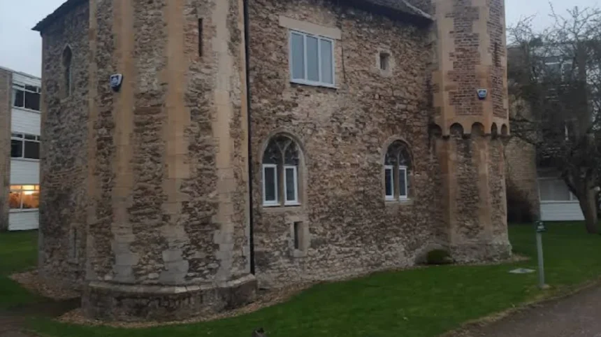
In the year 1217, King Henry III transferred the lucrative patronage of Chesterton parish church to Cardinal Guala Bicchieri, who served as the Papal Legate to England. This grant was executed as a formal gesture of royal gratitude for the diplomatic assistance provided by Guala in resolving the First Barons’ War. Cardinal Guala subsequently bestowed the manor and its accompanying ecclesiastical assets upon the Augustinian Abbey of Saint Andrew in Vercelli, located in northern Italy. To manage these valuable English assets and collect agricultural rents, the Italian canons constructed a permanent administrative headquarters within the vicarage grounds. This structure, known today as Chesterton Tower, remains a rare and fully preserved example of a mid-14th-century secular dwelling. The building features two storeys constructed from local field stones, clunch, brick, and ashlar quoins, complete with a stone-vaulted ground floor ceiling, a defensive spiral staircase, and an original garderobe.
Ecclesiastical governance remained tied to mainland Europe until geopolitical shifts forced a reallocation of the estate. In 1440, King Henry VI confiscated the property from the alien priory and granted it to King’s Hall, an early academic institution at the University of Cambridge. When King Henry VIII dissolved the monasteries and reordered the university system in 1546, he merged King’s Hall into his newly established foundation, Trinity College. Consequently, Trinity College assumed the historic manorial rights, land ownership, and church patronage of Chesterton. This institutional stewardship preserved the medieval parish boundaries and shaped local agricultural policies for the subsequent three centuries.
What Was the Impact of the 1840 Enclosure Act?
Prior to the mid-19th century, the economic life of Chesterton depended almost entirely on the traditional open-field farming system. The arable land of the parish was divided into three vast, unhedged communal fields known as West Field, Middle Field, and East Field. Local farmers cultivated these fields in scattered strips, relying on ancient customary laws enforced by the manorial courts to manage crop rotation and livestock grazing. This agrarian structure restricted rapid urban development and kept the population clustered tightly around the historic High Street and St Andrew’s Church.
The passage of the Chesterton Enclosure Act in 1838, which culminated in the formal execution of the enclosure award in 1840, permanently dismantled this medieval system. Enclosure eliminated all communal farming rights, reorganized the scattered strips into consolidated blocks of private property, and ring-fenced individual allocations. Wealthy investors and existing landowners acquired extensive tracts of freehold and copyhold land across the parish. For example, the industrialist Thomas Riddel received a substantial land allocation surrounding his pre-existing windmill on Milton Road, turning the area into a private estate. The physical transformation of the landscape was immediate as developers laid out new roads across the old open fields, creating straight transportation corridors such as Histon Road and Victoria Road.
Enclosure acted as the primary catalyst for the rapid urbanization of the area. Land along the southern and western perimeters of the parish was quickly sold to speculative builders who constructed high-density housing blocks. This process initiated the development of New Chesterton, a distinct working-class residential district that grew along Victoria Road and Chesterton Road. This rapid spatial expansion drew thousands of industrial laborers, artisans, and transport workers to the district, setting off an unprecedented demographic explosion.
How Did Industrialization and the River Cam Shape the Area?
The River Cam served as the primary commercial lifeblood of Chesterton during the 18th and 19th centuries, linking the rural parish directly to the industrial network of the East of England. Before the expansion of the railway system, heavy goods traveled primarily by water. Large commercial barges transported coal, timber, grain, and building materials from the ports of King’s Lynn and Ely directly into the heart of Cambridge. The riverbanks of Chesterton became bustling industrial wharves, lined with malthouses, brickworks, lime kilns, and structural iron foundries.
This intense river traffic created a unique commercial culture focused around the waterfront. The numerous public houses built along the Chesterton riverfront became essential refueling stations for the bargees, who were the commercial river workers responsible for steering the heavy cargo boats. Pubs such as The Green Dragon, which dates back to the 16th century, and The Old Spring provided lodging, trade spaces, and stables for the heavy horses used to tow the barges along the river paths. The concentration of these establishments turned Chesterton High Street and the riverfront into an energetic commercial zone that operated independently from the university-dominated economy of central Cambridge.
As the 19th century progressed, the mechanization of local industry consolidated the industrial character of the suburb. The construction of the Cambridge Gasworks on the opposite bank and the growth of large manufacturing operations within Chesterton, including the Leys Laundry and local printing operations, established the area as a principal manufacturing center. The transition from river-based transport to rail transport began to take shape during the mid-1840s when the Eastern Counties Railway laid down tracks through the eastern edge of the parish. This shifting infrastructure laid the foundation for the heavy industrial zoning that characterized East Chesterton throughout the 20th century.
Why Did Chesterton Fight Annexation by Cambridge?
The administrative relationship between Chesterton and the borough of Cambridge was defined by prolonged political conflict regarding local governance, taxation, and independence. Although Chesterton grew physically connected to Cambridge due to the rapid expansion of New Chesterton, the community remained legally separate. It was governed by its traditional parish vestry and manorial courts rather than the urban municipal corporation. In 1880, due to overcrowding and sanitation needs, the parish upgraded its administration by forming an elected local board, which subsequently became the Chesterton Urban District Council under the Local Government Act 1894.
The Cambridge Borough Council launched several aggressive political campaigns to annex Chesterton to expand its tax base and unify urban public health services. The independent electorate of Chesterton strongly resisted these takeover attempts. The primary driver of this resistance was economic, as home owners and local businessmen wanted to avoid the significantly higher municipal tax rates levied by the borough of Cambridge. Local identity also played a decisive role, with residents viewing Chesterton as an independent, self-made working-class town distinct from the university-dominated governance of Cambridge.
On three separate occasions between 1897 and 1909, the Chesterton electorate voted overwhelmingly against amalgamation. However, the continuous growth of the population eventually made separate administration unmanageable. In 1912, the British Parliament passed a formal boundary amendment that abolished the Chesterton Urban District Council. The southern third of the historic parish, including the medieval village center and the dense rows of New Chesterton, was formally annexed into the borough of Cambridge. The remaining rural northern territories were temporarily transferred to the neighboring parish of Milton, ending a century of hard-fought administrative independence.
How Did the Modern Suburb Evolve into a Tech Hub?
Following its incorporation into Cambridge, Chesterton evolved through large-scale municipal housing developments and modern transport planning. During the interwar and post-World War II eras, the City Council cleared older industrial sites to build extensive public housing developments. Large housing estates expanded across East Chesterton and areas bordering King’s Hedges, altering the local demographic makeup by introducing hundreds of working-class families into modern, planned residential environments.
The late 20th and early 21st centuries brought a profound economic shift as heavy manufacturing declined and gave way to knowledge-based industries. The modern transformation of the area accelerated dramatically with the development of the Cambridge Science Park and the St John’s Innovation Centre, positioned immediately along the northern boundary of Chesterton. This concentration of high-technology firms, biotech enterprises, and research laboratories integrated Chesterton into the global technology phenomenon known as the Silicon Fen. Consequently, the local housing market shifted, with traditional Victorian terraces undergoing extensive modernization to accommodate technology professionals and research academics.
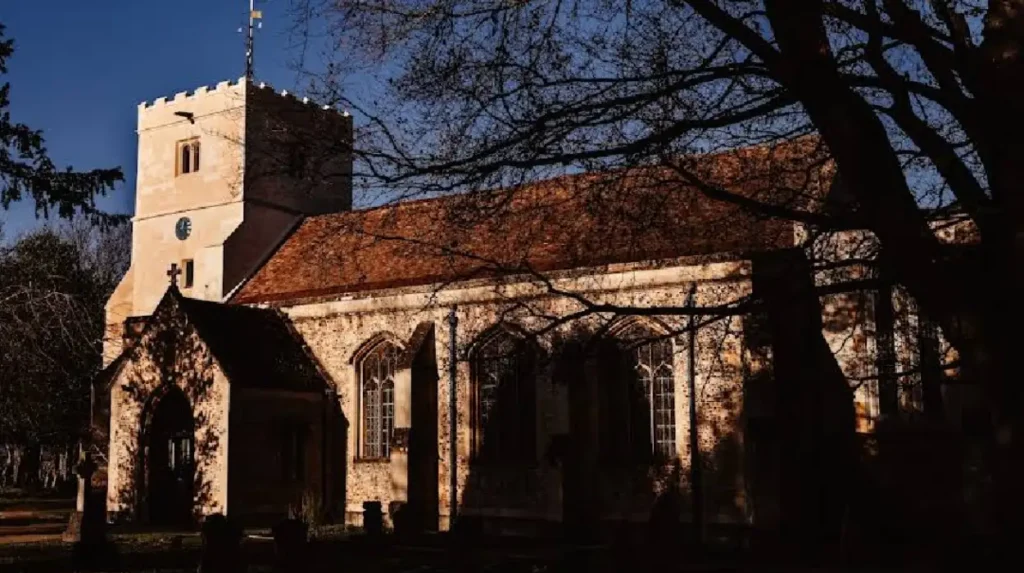
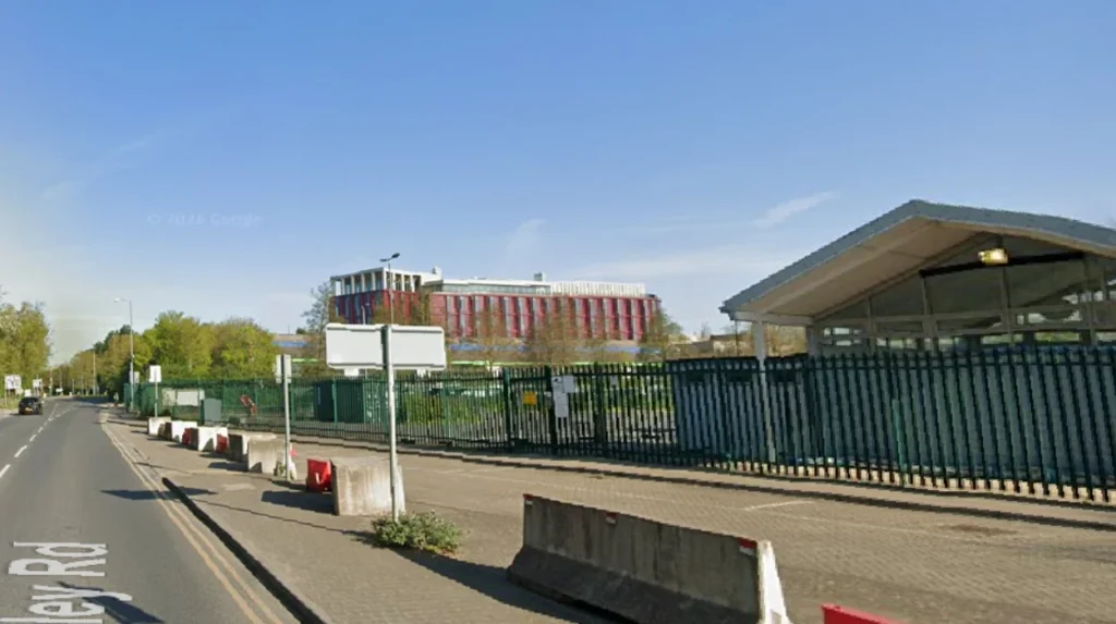
The most critical infrastructure upgrade occurred in May 2017 with the official opening of the Cambridge North Railway Station in East Chesterton. This multi-million-pound transport hub, built on former railway sidings, established direct rail connections to London King’s Cross, London Liverpool Street, and Europe via Ely. The opening of the station stimulated substantial commercial and residential redevelopment across the old industrial freight yards, resulting in the construction of modern apartment buildings, corporate offices, and retail facilities. Today, Chesterton blends its preserved medieval heritage, such as Chesterton Tower and St Andrew’s Church, with its role as a well-connected, high-technology urban hub.
Related Articles
- What is the Cambridge Folk Festival and how did it become a landmark event?
- Land lease approved for Cambridge affordable housing project
FAQs About History of Chesterton Cambridge
What is the historical significance of Chesterton Tower?
Chesterton Tower is a Grade I listed 14th-century stone building constructed to house the foreign procurators of the Abbey of Vercelli. It represents a rare, structurally intact example of mid-medieval secular architecture within Cambridgeshire, featuring original stone vaults and a complete defensive layout.
When was Chesterton formally incorporated into the city of Cambridge?
The southern urbanized sections of Chesterton were formally annexed into the borough of Cambridge in 1912. This occurred following the dissolution of the Chesterton Urban District Council and despite three previous local referendums where residents voted to maintain their independence.
How did the 1840 enclosure transform the geography of Chesterton?The 1840 enclosure award abolished the ancient open-field farming system, dividing the land into privatized holdings. This structural shift allowed developers to build new thoroughfares like Victoria Road and layout the dense residential neighborhoods known as New Chesterton.
What role did the River Cam play in Chesterton’s industrial development?
The River Cam operated as a major commercial transport corridor for barges carrying coal, grain, and timber. This constant traffic led to the development of industrial foundries, brickworks, and a dense concentration of riverside public houses that supported local watermen.
What is the closest railway station to Chesterton today?
The closest facility is the Cambridge North Railway Station, which opened in May 2017 in East Chesterton. This station provides direct commuter access to central London and has driven the recent economic transition of the surrounding industrial zones into modern commercial developments.