uk/local/newnham/">Newnham lies on the south‑western edge of Cambridge city centre, wrapped around a sweeping bend of the River Cam and intersected by small watercourses such as Bin Brook. The area includes Grantchester Meadows, Paradise Nature Reserve, Newnham Croft and streets such as Newnham Road and Newnham Terrace that sit on low ground adjacent to the river corridor.
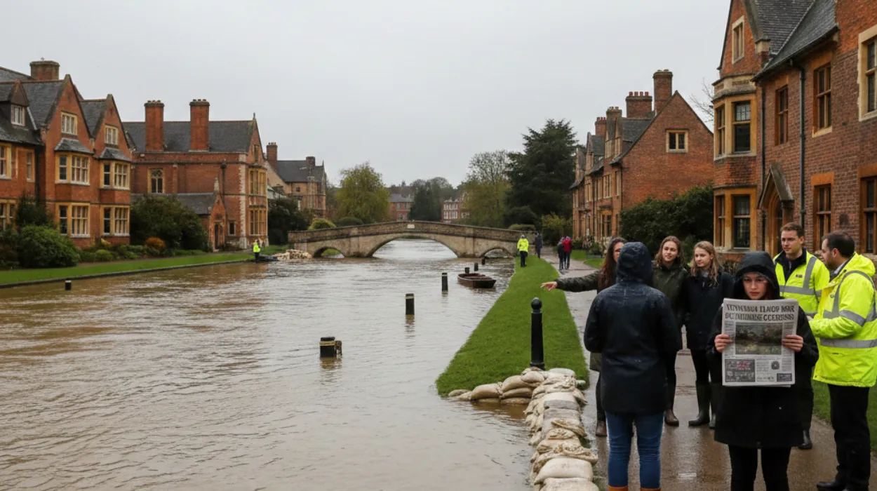
This attractive waterside setting is also the reason flood risk is a persistent concern for residents, schools and local businesses. When river levels in the Cam or Bin Brook respond rapidly to prolonged or intense rainfall across the Cam catchment, water can spill out of channel into fields, paths, nature reserve land and, in notable events, approach property thresholds on nearby streets.
Newnham benefits from its network of green spaces, which act as informal flood storage and allow water to spread across meadows and nature reserves before it reaches built‑up streets. Paradise Nature Reserve and the grazing meadows along Grantchester Meadows play a particularly important role in this natural attenuation function. However, this capacity is not limitless, and strategic planning documents for Greater Cambridge identify the river corridor here as a key band of fluvial flood risk that must be carefully managed as the city grows.
Types of flood risk affecting Newnham
Flood risk in Newnham is not a single issue but a combination of several mechanisms that interact with one another. Understanding each type of risk is essential for long‑term, evergreen guidance relevant to residents, planners and property buyers in the area.
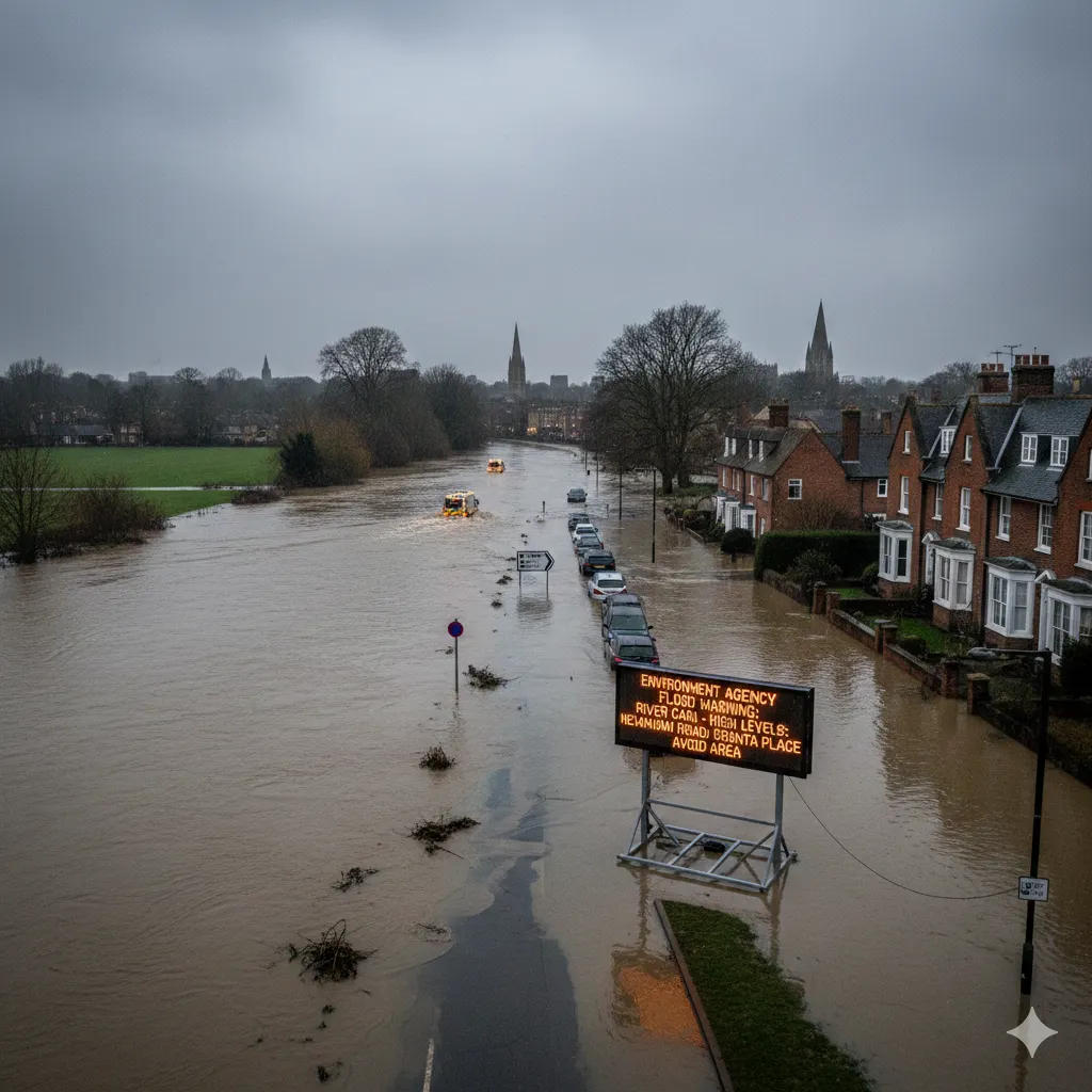
Fluvial flooding from the River Cam is the most visible and widely recognised source of risk in Newnham. Environment Agency flood warning areas explicitly list streets including Newnham Road, Newnham Terrace, Granta Place and the meadows between Grantchester and central Cambridge as locations where river water may threaten roads, paths and properties during high flows. These warnings typically relate to periods of sustained rainfall over the wider Cam catchment, which can raise river levels over several days.
In addition to the main river, Newnham is influenced by the behaviour of smaller watercourses, notably Bin Brook. The Environment Agency and third‑party services maintain a distinct flood warning area for “low‑lying areas close to Bin Brook at Newnham,” reflecting the fact that this local brook can overflow and affect adjacent land and homes independent of major events on the Cam. This localised fluvial flooding can occur more rapidly because small catchments respond quickly to intense rainfall.
Surface water flooding, sometimes referred to as pluvial flooding, is a further concern for parts of Cambridge, especially where urban surfaces and limited drainage capacity cause heavy rain to pond on roads, footpaths and low‑lying gardens. The Strategic Flood Risk Assessment for Cambridge notes the importance of considering surface water flows alongside river flooding, particularly in areas with complex drainage networks and constrained outfalls into the Cam. Although specific surface water hotspots vary street by street, any low point close to the river or a culverted watercourse in Newnham can be vulnerable during cloudbursts.
Another source of risk is groundwater and sewer interaction. While the Environment Agency’s public maps focus mainly on flooding from rivers, the sea and surface water, local guidelines for Greater Cambridge stress that high groundwater levels, combined with surcharged sewers, can exacerbate flooding in low‑lying neighbourhoods. In practice, this means that during long wet winters, the capacity of underground systems in Newnham may be stressed, making overland flooding from smaller rainfall events more likely.
There is also a residual risk associated with any formal or informal flood defences and drainage infrastructure in the Cambridge area. Even where embankments, culverts, sluices or engineered channels reduce day‑to‑day risk, there remains the possibility of failure or overtopping during exceptional events. Planning guidance for the city therefore assumes that flood risk can never be completely eliminated, only managed and mitigated.
Evidence of flood risk in official maps and assessments
Flood risk in Newnham is documented in a range of authoritative mapping and policy sources that inform both personal decisions and strategic planning. Online flood‑risk tools, strategic assessments and local plan evidence collectively show that the area sits within defined zones of fluvial flood potential.
The UK Government’s “Check for flooding” service includes designated flood warning areas covering the River Cam corridor through Newnham. One such area, “Wider area at risk from the River Cam at Grantchester and Chesterton,” lists Grantchester Meadows, Newnham Road, Newnham Terrace and Queens Road among the locations for which residents can register for advance flood warnings. A related area for “low lying areas close to the River Cam at Grantchester and Cambridge” similarly covers Newnham’s riverside streets, indicating the official recognition of fluvial risk around the neighbourhood.
Independent mapping services drawing on Environment Agency data classify Newnham postcodes according to flood risk bandings such as high, medium, low or very low. These postcode‑level maps highlight that areas closest to the river channel and its immediate floodplain have higher annual probabilities of river flooding, while properties further back from the watercourse sit in lower risk categories. Such data can guide mortgage lenders, insurers and homebuyers when assessing long‑term exposure.
At the planning policy level, the Greater Cambridge Strategic Flood Risk Assessment (SFRA) provides a city‑wide view of present and future flood risk. The latest Level 1 SFRA and earlier assessments identify the main bands of fluvial floodplain along the River Cam through Cambridge, including the reaches that run past Grantchester, Newnham and into the historic city core. These documents collate Environment Agency flood zones, modelled future flood extents, historic flood incidents and existing flood management infrastructure, offering the evidence base that underpins local plan decisions.
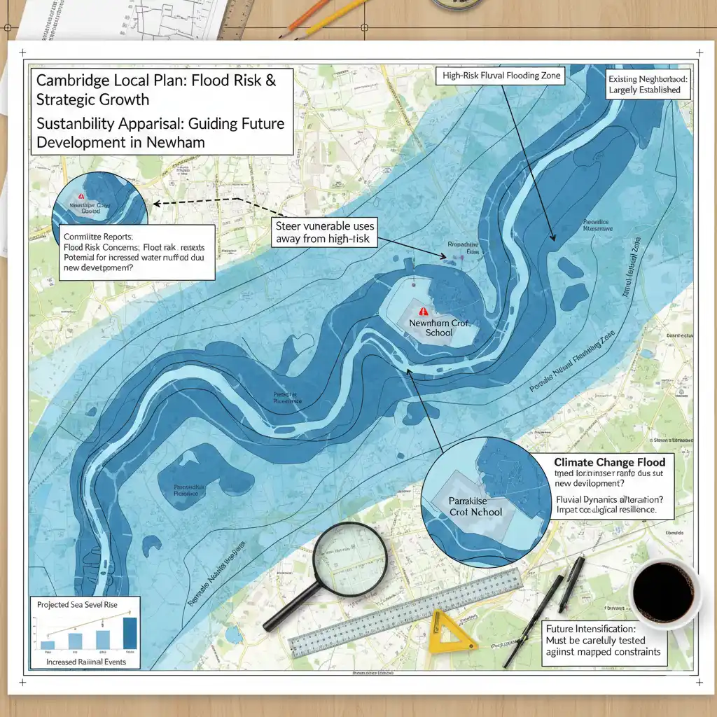
The Cambridge Local Plan and associated Sustainability Appraisal acknowledge that areas adjacent to the River Cam are particularly sensitive to fluvial flooding and climate change. Earlier sustainability appraisal work notes that strategic growth must consider the constraint posed by the river floodplain and recommends steering the most vulnerable uses away from high‑risk zones. For Newnham, this means that while the existing neighbourhood remains largely established, future changes and intensification must be carefully tested against these mapped constraints.
Alongside high‑level assessments, detailed planning documents occasionally highlight specific Newnham locations where development proposals could have implications for flood risk. For example, committee reports have raised concerns about potential increased flood risk to Newnham Croft School and Paradise Nature Reserve if additional built development in the area altered local surface water or fluvial dynamics. These case‑specific discussions illustrate how flood considerations shape decisions even at the individual site scale.
Climate change and future flood risk in Newnham
The influence of climate change on future flood risk is central to modern planning and community resilience strategies in Cambridge. Official guidance emphasises that increased winter rainfall and more frequent extreme rainfall events are likely to change both the frequency and severity of flooding over coming decades.
The Greater Cambridge SFRA explicitly incorporates climate‑change allowances when mapping future flood extents and modelling river flows. Higher peak river discharges are used to simulate how the Cam and its tributaries, including reaches passing Newnham, might respond in a 2050s or 2080s climate scenario compared to historic baselines. This modelling indicates that areas currently mapped as Flood Zone 2 (medium probability) could experience risk levels more akin to present‑day Flood Zone 3 (high probability) under extreme climate‑change allowances.
For Newnham, this forward‑looking analysis implies that low‑lying meadows, riverside paths and parts of nearby streets could see more frequent inundation, especially during winter storm sequences. While flood defences, channel management and upstream catchment measures may offset some of this increased risk, planning policy assumes that residual risk will remain and may, in fact, grow. As a result, the area’s flood‑sensitive status is unlikely to diminish in future local plans or insurance assessments.
Climate change also affects surface water and groundwater behaviour, not just river flows. More intense downpours can overwhelm urban drainage systems and lead to flash surface water flooding on roads, footpaths and properties, even where river levels are not at their highest. In Newnham, with its mixture of older housing stock, small streets and nearby watercourses, the combined effect of higher river baselines and more intense rainfall may make integrated water management approaches increasingly important.
Local and national guidance therefore encourage a precautionary approach in flood‑prone areas like Newnham. New development is expected to adopt higher resilience standards, and existing property owners are advised to consider adaptive measures such as property‑level protection and flood‑resilient refurbishment, recognising that what is considered an “exceptional” event today may become more common in the future.
Planning policy, development control and flood‑conscious growth
Planning authorities in Cambridge operate within national policy frameworks that require a rigorous approach to building in flood‑risk areas. The National Planning Policy Framework (NPPF) mandates the use of the Sequential Test and, where necessary, the Exception Test to steer development away from the highest flood‑risk zones whenever possible.
In Greater Cambridge, the SFRA provides user guidance for applying these tests, ensuring that local plans and planning applications systematically consider flood risk. For Newnham, this means that any proposal for new housing, community facilities or infrastructure in or near the mapped floodplain must demonstrate that: alternative, lower‑risk locations have been considered; the development is compatible with the degree of risk; and robust mitigation measures are built into design and layout.
The Cambridge Local Plan and supporting documents emphasise that development in functional floodplain (areas that flood frequently and are designed to store water) should be strictly controlled. In Newnham, this covers parts of the river meadows and nature reserve land, which act as critical overland flow routes and temporary storage during high flows. Constraining built development in these areas helps protect both local and downstream communities by preserving the natural capacity of the river corridor.
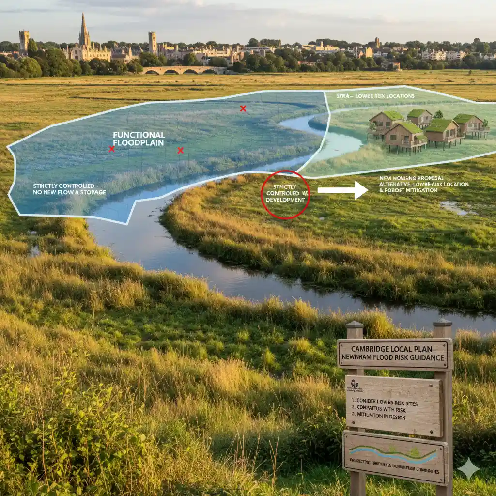
Where development is considered acceptable in principle, detailed site‑specific flood risk assessments are required. These assessments must draw on the latest Environment Agency data, SFRA findings and climate‑change allowances to model flood extents, depths and velocities for a range of scenarios. For Newnham, modelling would typically consider overtopping of the River Cam or Bin Brook, blockage of culverts and interaction with surface water pathways.
Local planning reports illustrate how flood considerations shape individual decisions in and around Newnham. Concerns have been raised that certain proposals could increase flood risk to sensitive receptors, such as Newnham Croft School or Paradise Nature Reserve, by altering surface water routes or reducing storage capacity. In such cases, planners may require redesign, additional mitigation or, where necessary, refusal to ensure that development does not exacerbate existing flood challenges.
The Cambridgeshire Flood and Water Supplementary Planning Document (SPD) provides further guidance on integrating sustainable drainage systems, water efficiency and flood resilience into new developments across the county. The SPD promotes measures such as permeable paving, green roofs, swales and attenuation basins, which can be particularly valuable in edge‑of‑city neighbourhoods like Newnham where urban and semi‑rural drainage patterns meet.
Managing and mitigating flood risk for homes and community
Living near the River Cam brings both amenity value and flood‑related responsibilities. National and local guidance stress that flood risk can be managed effectively when communities, authorities and individual property owners work together and plan ahead.
Residents in Newnham are encouraged to understand their specific level of flood risk by checking postcode‑based maps and the official “Check for flooding” service. These tools allow people to identify whether their property lies within a flood warning area for the River Cam or Bin Brook and to sign up for free warnings by phone, text or email. Receiving timely alerts can provide crucial lead time to move possessions, deploy property‑level protection and avoid unnecessary travel along riverside roads and paths during high flows.
Insurance and mortgage decisions also reflect local flood characteristics. Insurers use Environment Agency data and third‑party flood maps to assess the probability and potential severity of flooding for individual postcodes. In higher‑risk parts of Newnham, homeowners may face specific conditions or premiums, but the availability of insurance is supported nationally through frameworks that recognise the importance of long‑term flood‑risk management and resilience measures.
Practical property‑level measures can significantly reduce damage if flooding does occur. Common interventions include raising electrical sockets, using water‑resistant materials on ground floors, installing flood doors or barriers, and fitting non‑return valves on drainage pipes to prevent backflow. When combined with community‑scale drainage and green‑infrastructure solutions, these steps help keep recovery times and long‑term impacts manageable.
Community resilience is enhanced when local groups, schools and institutions are aware of flood plans and potential evacuation or shelter arrangements. Guidance from flood‑risk programmes encourages communities in at‑risk areas to develop local flood plans, identify key contacts and ensure that vulnerable residents are supported if warnings are issued. In a neighbourhood like Newnham, where many people regularly use riverside paths, rowing facilities and meadows, clear communication about temporary path closures and safe access routes during high water is especially important.
Although Newnham has historically avoided very frequent, severe river flooding, the presence of designated flood warning areas and strategic flood‑risk mapping means that vigilance remains essential. By combining individual preparedness, informed planning decisions and long‑term adaptation to climate change, the community can continue to enjoy its riverside environment while managing the inherent flood risk associated with living beside the River Cam.